Monday, November 29, 2010

Juneau Alaska Part 2: the Mendenhall Glacier

The first thing my relatives took me to see when they picked me up at the airport was the Mendenhall Glacier.  I was so fascinated that I used my last day in Juneau to visit it again, going for a much longer hike around the lake and up the side to a viewpoint above the river of ice.  Here's me holding a chunk of glacial ice that I picked up from the Mendenhall Lake:


And my cousin Maddy and I near a waterfall, with the glacier in the background:


In theory, I have seen glaciers before.  In Wyoming and Colorado I've seen patches of snow high in the mountains that never melt.  But a real, active glacier is entirely different.  It really is a river of ice.  The Mendenhall glacier is one of several glaciers flowing out of the Juneau Icefield, which an area of mountains where snowfall always exceeds the melt.  Snow builds up, compacts into beautiful, deep blue ice, and is squeezed out into glaciers that run the excess ice out to lower ground (or sometimes directly to the sea).  It's like a giant lake of ice with ice rivers spilling out over natural dams.   Here's a picture that really shows the river nature of the glacier:


The glacier flows at a rate of about two feet a day, and is about 12 miles long, measuring from the icefield to the Mendenhall Lake.  That means it takes upwards of 80 years for ice to travel from the icefield to the lake.  Add 20 years for snowfall to compact and make its way through the icefield, that little chunk of ice in my hand a few pictures back was 100 years old!  Pretty cool! 

Maddy and I climbed up the valley above the glacier to get some good views.   Here's a look back down the valley towards the lake:


And here's a closeup of the lake (now freezing over, because it's November) with icebergs floating in it:


 On the way back down we took a detour down a largely unmarked trail (Caution! Dangerous Unmaintained Trail Ahead!) to go touch the glacier.  We had to hurry because the light was fading fast (sunset is at about 3:30 Juneau in November) Here's Maddy leading the way:


And finally, here's the edge of the glacier, where bedrock meets ice, with a layer of sand grinding away in between. 


Happy with our success, we hurried back to the car before it got dark.  On the way out, we ran into a mamma bear with two cubs.  By the time we noticed them, momma bear had sent the cubs up a tree and was watching us from behind the trunk.  They were quite close, so we raised our hands over our heads (to look bigger) and continued chatting loudly while we walked past.  Quite exciting!  I'll confess that I didn't get a picture of the bears (there were too many other important things to think about at the time) but I did get a picture of a snowshoe rabbit hiding under a tree:


And just to polish things off, here's a neat picture of ice forming on a puddle:


Thanks Maddy for a great hike!

Juneau Alaska Part 1: Background

On November 7th I left my car (my home for the last two months) behind in Seattle and flew up to Juneau, AK to visit my aunt, uncle and cousins.  Here's a map of Alaska to give you an idea of where Juneau is (hint: it's in the lower right of the image):


Juneau is the state capital, but you can't get there by car.  It's on the mainland, but the mountains are steep and rugged, and it has never been worth the investment of putting a road to Skagway, the nearest town connected to the outside world via a road.  There is a road, but it only goes about 5 miles to the south and 50 miles to the north.  Everything in Juneau arrives by boat or plane, including the entire state legislature whenever they are in session.  Here's a closeup of southeast Alaska:


Sort of like Seattle, Juneau is both on the coast and very protected from the open sea by large mountain islands.  The area actually looks like a submerged mountain range, with only the valleys underwater.  Here's a picture of downtown Juneau, taken from the docks.  The town is hidden in the narrow valley and the mountains loom just beyond:


The channel between Juneau and Douglas Island is very narrow, deep in some spots and shallow in others.  At extreme low tides you can wade (through deep mud) from one to the other north of town about 20 miles.  But high tide is around 15 ft higher than low tide, the undertow is fierce, and the water is very cold, so I wouldn't advise trying it. 

Juneau is an unlikely spot for a town, let alone a state capital, but it was originally the site of a huge gold mine.  It is closed now, but the mountains around Juneau are riddled with mining tunnels, downtown is built on the mine tailings, and Gold Creek, which runs down the valley, has abandoned mining equipment and mills all along it.  My cousin Maddy took me hiking all around Gold Creek and showed me the town cemetery where the prospector Joe Juneau is buried. 

Before the gold rush, this part of southeast Alaska was mostly populated by the Tlingit people, and the Native culture is still a big part of the city.  I went to two lectures on Native issues while I was there, learning about some of the local oral history, and how various stories correspond to known events, like glacier movements thousands of years ago, or more recently, early encounters with Russian and American troops.  Here's a picture of a Tlingit totem pole:


The next few posts will show the places I visited and sights I saw while in the Juneau area.

Saturday, November 20, 2010

Seattle Part 5: Excursion to Lopez Island

My final Seattle adventure was a trip to one of the San Juan Islands, north of the city.  The San Juans are up near Canada, not technically in Puget Sound, but still shielded from the open ocean by Vancouver Island.  Due to some local geography, they are in a relative rain-shadow, receiving about 20 inches a year, while Seattle gets about 35.  Parts of the Olympic Peninsula (like the rain forest I visited in the last post) get over 200! 

I only visited one island, Lopez, which is known for farms and for being very bicycle-friendly.  I took the ferry to the island, and made the decision that I would leave my car on the mainland, bringing Joe's mountain bike and a pack filled with my tent and other gear.  Here's a picture of the ferry approaching the dock:


 From the dock I huffed and puffed with my heavy pack for a mile before I found my campground.  Not any surprise that it was empty, given that it was mid-week in early November!  I set up my tent, stashed everything except a small day-pack inside, then hit the road.  Lopez is big enough to have a small town and lots of farmland.  I biked a loop roughly following the coast that was about thirty miles long.  Not bad!  Most of the interior is rolling farmland, like this:


 Just like when I was in Iowa and Nebraska, I was captured by the old barns.  Here are my two favorites:


Doesn't look like an island, but then I would turn a corner and have a view over the ocean:


Here's a fun picture of my shadow as I biked along.  The sun was sinking low and I was starting to head towards the town and some dinner:


Here's a picture looking across the harbor towards town:


The summer tourist season is well past, so there were only two restaurants open.  I noticed that one had a lot more cars parked out front - I figured that was a good sign, so I went there.  One burger and a bunch of sweet potato fries later I had listened to two guys at the next table talk about the hay crop, their kids' school and sports, etc.  Made me homesick for North Carolina! By then it was dark (but only 6:30) so I peddled back to the campground and spent the evening walking along the beach, watching the occasional boat going by.  The next day was colder and a little rainy, so I headed back to town and spent some time in the library.  It cleared as I headed back to the ferry, and I passed the local radio station:


Funny to think of such a small island having its own radio, but then, they probably don't pick up many stations from the mainland!  During the ferry ride, then car ride back to Seattle I watched the farmland go by.  I like the rural feel of the area north of Seattle. 

Friday, November 19, 2010

Seattle Part 4: Excursion to Olympic National Park

Since I had already celebrated Halloween (and eaten an insane amount of candy) on Friday, I decided to head out for an adventure on Saturday and Sunday.  The weather forecast showed rain everywhere, so rather than fight it, I opted to embrace the weather and headed to Olympic National Park, which is one of the few places officially classified as a temperate rain forest.  The area receives over 200 inches of rain a year, which averages out to more than half an inch a day!  I certainly got my inch and more during the two days I was there! 

I started off with a drive around the park, and camped my first night in the Hoh Valley Rain Forest.  I arrived there after dark and set up my tent in the pouring rain, so I didn't really get a look around until the next morning.  Here's a picture of me emerging from my tent:


Note the rubber boots.  They are essential equipment on the Olympic Peninsula, and quite handy in Seattle as well!  Also note that I'm still smiling.  My tent passed its test by keeping me as dry as one can reasonably expect to be after a night of steady, hard rain. 

Hiking through the rain forest I got an idea of just how much water falls in this area.  Trees compete for sunlight, so the forest floor is quite dark:


There are light patches wherever a tree has fallen, opening a hole in the canopy and allowing smaller trees to grow:


Sunlight is in short supply, but the real battle is over nutrients.  The soil is acidic from all the fallen pine needles, and most vital nutrients are locked into existing trees.  There are various strategies that plants take to gain nutrients.  Mosses and ferns coat all the trees, taking nutrients from the bark and getting access to sunlight.  Here's a close-up of one tree trunk:

And another:


Young saplings often grow on fallen trees, taking nutrients from the decaying log before it has time to become soil again.  These fallen trees are called "nurse logs" and can often have a line of younger trees growing out of them:


Years later, after the nurse log has rotted, the grown trees will still have their roots above ground, curled around each other and the phantom remains of their nurse log host:


Leaving the rain forest, I drove through the small town of Forks, WA.  I saw a group tourists, mostly teenagers, crowded around the "Welcome to Forks" sign, and soon figured out why: Forks is the setting for the popular Twilight series (I felt a little behind the times, not being up on my teenage vampire lore).  The author was looking for a good place for her vampires and werewolves to live, and settled on Forks as the town with the fewest number of sunny days in the US.  The town has embraced its sudden fame, with Twilight signs everywhere:


Leaving vampires behind I headed for the coast, with a brief stop to see the world's largest Western Red Cedar, which has a diameter of nearly twenty feet!


Then I hit the coast, which is covered with volcanic rocks sticking up everywhere.  Notice that I'm still wearing the rubber boots:


Here's a picture of the sun peaking through the clouds, shining down on the beach:


And finally, I went exploring in the tide pools:


Then I headed back to Seattle, arriving at dusk, just as kids were swarming the streets in their costumes, looking for their share of Halloween candy. 

Thursday, November 18, 2010

Seattle Part 3: Excursion to Mt. Si

One sunny day I left Joe's apartment early and headed east on I-90 for a day hike up Mt. Si, one of the most hiked mountains in Washington.  It started out in a shady, damp forest full of ferns and mosses:


And then topped out on a rocky outcropping.  The trail stopped below the bare rock, and signs said to proceed with caution.  Thinking that didn't sound too bad, I proceeded.  Then fifteen minutes later, scrambling up the rock face with cold wind freezing my fingers, I changed my mind.  Unfortunately, at that point I realized that it is much harder to climb down a rocky outcrop than it is to go up it.  After a few tense moments and the use of some of the rock-climbing skills Joe had shown me the night before, I got back below treeline.  I snapped a quick photo as a hurried down out of the wind:


On the way down I stopped at one of the overlooks. Here are the mountains to the south:


A little more to the east, Mt. Rainier stands up above the normal sized mountains like a snow-covered giant.  I never made it to Rainier, but its presence is felt everywhere in the Seattle area:


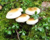
Then on the way back down I started noticing mushrooms.  In this wet climate they grow everywhere!  Here's a mushroom medly for you, just a small sampling of what I saw hanging out on the forest floor:


Finally, for those of you who have read Blue Highways, I had an encounter with what I think is a banana slug:  


I'd count this day hike as a success!

Seattle Part 2: Being a Tourist

Besides just mooching Joe's social life, I also spent a fair amount of time being a tourist in Seattle.  One rainy weekend day Joe took me to the Woodland Park Zoo.  There weren't very many other people around (it was REALLY raining, not just the usual Seattle Mist), but we had a good laugh at ourselves as we sloshed our way past soggy bears, dripping kangaroos, and damp tigers, ducking into protected bird and reptile houses whenever the rain got too strong.  In front of the raptor bird house we met my first typically friendly Seattleite.  This woman was standing with a peregrine falcon perched on her wrist, waiting for interested zoo visitors to ask questions about birds of prey.  We were the only ones there, so she talked to us about birds, Seattle, how much she loves it in the city, and so on.  She says all this while standing in the pouring rain, hood up, water dripping off her nose! This is someone who LOVES Seattle, and I found the attitude to be common in the city.  On the bus, at cross-walks, in cafes and in the public park, everyone laughs about the drizzle; it seems that the weather makes people chatty and friendly.  Here's a picture you've seen before, a damp tiger at the zoo:


On weekdays while Joe was at work I alternated between spending rainy days parked in a cafe or museum and drier days seeing the sights.  I visited Pike Place Market, where fish are tossed around at the fish market and the levels of shops selling antiques, books, clothes, etc wind and twist together in a 3-D maze.  Then I headed out to see some of the natural wonders of the area.  Here's a picture of the Chittenden Locks, where fresh water and salt water are kept separate.  Boats come into the locks at one level, and water level in the locks is raised or lowered to match the out-going side.  Finally, the other gate is opened, and the boat is free to move on:


Beyond the locks there is a fish ladder for the local salmon.  By November most of the fish have moved upstream, but there were still a few swimming by.  Continuing up the hill to Discovery Park I spent the afternoon (in my Halloween dinosaur costume) exploring the woods and coastline, with occasional views of downtown Seattle.  First, some evidence of Fall:


Next, the lighthouse on the point. 


Looking back towards downtown Seattle from the lighthouse.  If you click on the picture to look closer you might be able to see that the biggest cloud is not a cloud at all, it's Mt. Rainier standing guard over the city!


This is a look at the sandy bluffs along the coast.  They're not quite rock yet, but not as soft as normal soil, either.


One last look down on the harbor as I climbed back towards the park entrance and civilization:


With all its parks, Seattle is a good city for people who like green space mixed in with their downtown shops and stores!