Getting off the interstate I took the back way, following the Colorado River's canyon south and west. It's not quite the Grand Canyon that the Colorado carves down in Arizona, but it was still quite a sight to see, especially in the morning light:
Moab itself is an outdoor paradise. Arches and Canyonlands National Parks, plus Manti-La Sal National Forest and Dead Horse Point State Park, the list goes on and on. With only a few hours to spend in the area, I opted for "none of the above" and went for some lesser-known hikes in the BLM (Bureau of Land Management) areas. I picked highway 279 because it had several short hikes that would let me see arches, canyons, petroglyphs, and dinosaur tracks and would not be mobbed with people. What could be better?
It was incredibly hot, hotter than I thought was possible for the end of September (this was on Sept. 28, and it was easily in the mid 90s), but I had lots of water and a supply of tasty peaches, so off I went! Here's a bunch of pictures of Corona Arch (notice my pink face - it's hot!):
This one is a panoramic I took from underneath the arch, looking up. And then, one final picture of a second "arch" along the trail (it's more of a cave with a circular hole in the roof, but still very cool).

One thing pictures can't show is the absolute silence of the place. The arch is about a mile and a half up a small trail, and I only saw one other couple on the trail, leaving as I was starting my hike. It was so hot, nothing was moving, just a few lizards skittering across the sand on their way from one shadow to the next. No planes flying overhead, no cars driving by, no footsteps, no voices, no wind in the trees, no running water, just silence. It was a quite an experience, and I had it again on each of my hikes in Moab, as soon as I was out of sight of my car.
The next hike was a double whammy: Petroglyphs and dinosaur footprints. I scrambled up some rocks and around a corner to find them both. Unfortuantely, the petroglyphs had been defaced. So here are the dino tracks only:
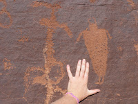
On the next hike, where the petroglyphs were not advertised at the trailhead, I just was lucky enough to be looking up at the right time, and then scrambled up to them (and almost got stuck when I tried to take a different way back down... oops!)
There were also herds of animals and groups of dancing figures, quite an impressive arrangement of figures, looking like they had been done in batches at different times.
My final hike for the day took me up to the top of the cliffs to the plateau above. I wasn't expecting what I found: a bizarre landscape of petrified sand dunes, and off in the distance, a formation that I believe is called "The Needles".
With my water supply running low and several hundred miles between me and my final destination for the day, I decided it was time to head back to the car. I'd like to come back to Moab sometime when I have a week or more to spend really exploring.


No comments:
Post a Comment